Geog 1700: Natural Disasters
GEOG 1700 – Natural Disasters (PS) 3 credit
Course introduces natural disasters and the related energy and processes which cause them. An awareness of the impact on human activity is an integral component, investigating methods of prevention, preparation, and mitigation of damage.
This is an interesting Geography course about Natural Disasters. Focused mostly on earthquakes, volcanoes, hurricanes, and tsunamis.
Natural Disaster signature assignment
Part 1: Tracking earthquakes
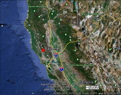
Magnitude- 4.5
Location- 38.812°N 122.786°W 5 km WSW of Cobb California
Date- 3-14-2013
Time- 9:09:23
Depth- 2.2 km (1.4 mi)
Type of tectonic plate boundary- Transform Fault
Why- Though there are not many on land I believe this earthquake was on a transform fault. It was very close to the San Andreas Fault that runs through 2/3 of California.
Part 2: Identifying Volcanoes
1. Volcano Name- Mount Fuji
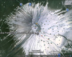
Volcano Type- Composite Volcano, Stratovolcano
Tectonic Plate Boundary- It sits near a continental convergent boundary, continental transform boundary, and an oceanic transform boundary.
2. Cerro Negro
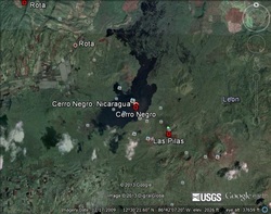
Volcano Type- Cinder Cone
Tectonic Plate Boundary- Convergent Plate
Tectonic Plate Boundary- Convergent Plate
3. Galapagos Islands
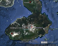
Volcano Type- Shield Volcano
Tectonic Plate Boundary- It is a convergent/destructive plate boundary.
Tectonic Plate Boundary- It is a convergent/destructive plate boundary.
4. Mount Okmok
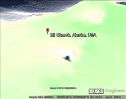
Volcano Type- Caldera
Tectonic Plate Boundary- Oceanic-Continental
Tectonic Plate Boundary- Oceanic-Continental
Part 3: Reflection
I had a few problems viewing these images. Mostly because they were hard to see from the aerial view, but when put into ground view they were too large to see. The more popular volcanoes, like Mount Fuji, had much better pictures. Mount Okmok in Alaska just looks like a big blob. I originally wanted to use Yellowstone as my caldera, but couldn’t find a good picture on Google Earth.
I have always thought about earthquakes in Utah as possible. When I was in elementary school I remember have “earthquake drills” and everyone hiding under their desks. The school I went to was very old and had huge glass windows everywhere so we learned what to do in case they shattered during an earthquake. Now that I understand plate tectonics a little more I think an earthquake in Utah is inevitable. I’ve heard many times that “the big one” is coming and I think that it is too. It’s only a matter of time. The hotel that I work at is huge and was specifically designed to withstand an earthquake. I hope I never have to find out if it will or not.
I have always thought about earthquakes in Utah as possible. When I was in elementary school I remember have “earthquake drills” and everyone hiding under their desks. The school I went to was very old and had huge glass windows everywhere so we learned what to do in case they shattered during an earthquake. Now that I understand plate tectonics a little more I think an earthquake in Utah is inevitable. I’ve heard many times that “the big one” is coming and I think that it is too. It’s only a matter of time. The hotel that I work at is huge and was specifically designed to withstand an earthquake. I hope I never have to find out if it will or not.
